Managing koala populations is complicated by their uneven distribution in complex environments. Ground-based surveys used to document numbers of this Australian species of conservation concern are time-consuming and often inaccurate, as canopy cover can reduce the probability of sighting all individuals.
A high-tech method based on drones and infrared imaging is being applied to monitor these mammals. Researchers developed an algorithm for locating the koalas using camera-equipped drones that detect heat signatures in a system with the potential to improve management of other threatened species and track invasive 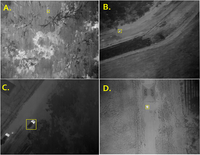 Objects automatically detected by drone-derived thermal imaging: (A) Candidate koala signature, (B) Kangaroo, (C) Car, (D) Human. Source: Queensland University of Technologyspecies.
The drones were tested during the early mornings of colder months, when differences between koala body heat and the background were likely to be greatest. After the aerial sweeps, recorded data were processed by an algorithm designed to identify the heat signatures of the koalas compared to other animals in the area.
The location of the koalas detected by the drones was correlated with the location of the koalas determined by their GPS tags, enabling researchers to rate the accuracy of the system. While ground-based spotters can count about 70% of koalas in a given area, the aerial system posted a probability of detection of 68% to 100%. The surveillance scheme is also faster and cheaper relative to reliance on human spotters.
Drones are finding increasing application in the wildlife management realm, and have been paired with artificial intelligence technology to count large mammals in nature reserves. Researchers have also demonstrated the utility of drones in monitoring polar bear and whale populations.
Researchers from Queensland University of Technology and Endeavour Veterinary Ecology Pty Ltd contributed to the koala counting study, which is published in Scientific Reports.
