Most unmanned aerial vehicles (UAVs), more commonly known as flying drones, come equipped with GPS technology in order to relay information about their location and surroundings and to avoid obstacles during flight.
But often, that GPS signal becomes unreliable when a drone is inside a city flying around buildings or in a forest area with dense foliage leaving drones blind.
Researchers at the University of Washington have developed a new method that gives UAVs a backup system in case GPS fails: an antenna on the ground that can communicate its location.
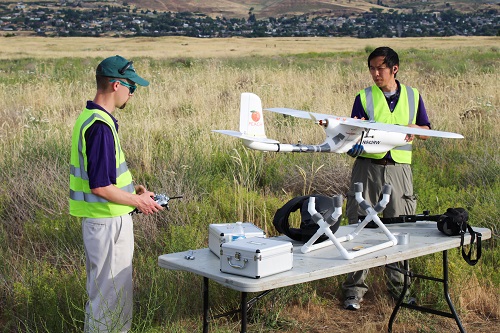 Researcher work on a drone with a transponder that is used to send signals when GPS fails. Source: University of Washington“Right now GPS is the one ring to rule them all: without it, tiny drones all the way up to commercial aircraft can’t do their jobs. It’s a huge liability,” said Christopher Lum, a UW research assistant professor of aeronautics and astronautics and the director of the Autonomous Flight Systems Laboratory. “Before GPS was widely used, pilots had myriad other techniques for navigation. Now we need to fall back to some of those older techniques to keep unmanned vehicles like drones in the air without GPS.”
The UW’s unmanned drones carry transponders on board that send signals to operators about their whereabouts. The transponder tells not just the drone about its location but everyone else as well so they can identify where it is.
If GPS is knocked out, the transponder doesn’t know its location but signals are still sent out. The team used a large ground-based antenna array to pick up the signals and then triangulate the position of the UAV.
“The ground station is smarter than the aircraft at that point,” Lum said. “We’re just modifying the autopilot onboard the aircraft. Instead of using GPS information to navigate, it’s listening to this message coming from the ground to figure out where it is.”
The University of Washington tested the system with a drone completing its 1.25-mile flight path without using GPS.
The team said the technique is cumbersome and right now it only works when the team is flying a drone at an airport with that antenna system. The next step is to increase the drones’ range, and the university is working with T-Mobile to try to use cellphone towers to perform the same function. Once the UAVs can fly larger distances without GPS, researchers hope to use them to help transport medical supplies to and from rural areas in Washington state.
