Light detection and ranging, or lidar, is one of the most powerful technologies available to give a machine a sense of its surroundings — and to provide a human operator with that data as well. It is most commonly known as a tool for autonomous vehicles, but lidar is useful for much more.
Terrain mapping is one of those applications. Understanding terrain is helpful in everything, from military operations to disaster relief to utility surveying. Recent innovations in lidar improves it capabilities in this realm, through a new technique called single photon lidar, or SPL.
Why is SPL better?
Lidar operates similarly to radar, except using light rather than radio waves. A laser of a known frequency is bounced off objects and are captured by a photodetector. Software then analyzes both the wavelength of the received photons and the length of time it took to receive them and translates those into spatial measurements, essentially detecting the distance to objects at the speed of light.
But some engineers think they can do better. SPL differs from traditional lidar in two important ways — the laser and the detector. Detectors on a traditional lidar setup measure the absolute intensity of the light bounced off the subject. These include detector types like photomultiplier tubes and PIN photodiodes. On the other hand, detectors in an SPL system are tuned to detect a single photon.
These devices, called a single-photon avalanche diode (SPAD) array, trigger an "avalanche" of electrons when struck with a single photon, creating a readable electrical signal. Their extreme sensitivity is one of the defining features of SPL. They have the bonus of detecting single photon arrivals at different times, allowing time-of-flight calculations for photons that bounced off objects at various distances.
SPL's second technological advantage over traditional lidar is its laser — particularly its speed. One metric of a laser is how quickly it can be turned on and off. Typically, the time between pulses gives the laser part of its name, such as a "microsecond laser." Laboratory prototypes have even been developed that have reached the femtosecond pulse range. However, those aren't suitable for commercial lidar systems yet.
Traditional lidar typically uses nanosecond lasers for applications like self-driving cars. However, for the more sensitive detectors used in SPL, the laser needs to be capable of turning on and off in an order of picoseconds — about 1,000 times faster than those used in traditional lidar.
With faster pulses and better detectors, SPL seems poised to take over the lidar space. However, it does have some disadvantages. It is obviously more complex than traditional lidar systems and, therefore, heavier and more expensive. This makes it challenging to implement on a chief burgeoning technology, like autonomous cars. It is also more susceptible to noise and failures of other system parts, such as timing electronics.
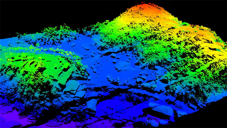
Despite these challenges, some research groups have started using SPLs in use cases where they shine, that being long-distance terrain mapping. A group led by Anu Swatantran, then a professor at the University of Maryland and now the leader of remote sensing and computer vision at Corteva Agriscience, mapped the entirety of Garrett County, Maryland, using an SPL in around 12 hours of flight time.
Mapping a County
Garrett County, which comprises the western corner of Maryland, is not a tiny place. Its total surface area is 1,700 km2 and is at least 70% forested. It also represents highly variable terrain, as it is part of greater Appalachia with its rolling wooded hills. Impressively, not only did the UMD team capture the county's terrain in under a day, but it did so down to a resolution of 2 m.
The equipment was mounted on an airplane that returned the data for review. To collect this data, they relied on green lasers, which are easily confused by vegetation. Given the high percentage of the county covered by trees, that might not have seemed the best design choice. Still, the team opted for significant post-processing of the data to eliminate any artifacts from leaves or background solar radiation, which that wavelength is also susceptible to. This processing included a series of filters to eliminate noise and increase accuracy.
The eventual result was an impressive topographical map of a relatively large area in a relatively short time. However, the UMD scientists were not the only ones interested in the technology. Last year, a team led by Feihu Xu from the University of Science and Technology of China published a paper that used SPL to map parts of Yiwu, a city in Zhejiang Province in China.
Lidar competition heats up
There are plenty of use cases for lidar, but with great potential comes great competition. Dozens of companies, including start-ups and established big players are interested in the lidar space, seeing it as one of the next big areas in sensor, especially its importance to the next generation of mobility technologies. It remains to be seen if SPL or a different technology will win out in the race to increase accuracy and speed while decreasing cost. Notably, some engineering teams, like ones from Leica in the video below, believe the best results will come from both SPL and linear lidar working together.
While that commercial battle is evolving, SPL will continue to be used in more and more applications as the lasers, sensors and algorithms used in SPL continue to improve. It won't be long before military field commanders, disaster relief responders and even a person's personal car will have up-to-date maps of the lay of the land around them.
