GPS navigation through digital maps has enabled people to get around much more easily than previous methods of learning routes or using handheld paper maps.
Yet, the task of mapping all roads is tedious, forcing companies like Google to spend many hours tracing out roads. And despite all of the routes Google has mapped, there are more than 20 million miles of roads across the globe yet to be mapped. This creates a problem for people in these areas where there are gaps in the maps and creates an even larger problem for self-driving cars.
In order to accelerate the generation of digital maps, MIT’s Computer Science and Artificial Intelligence Laboratory (CSAIL) has created an automated map-building method that’s 45 percent more accurate than existing approaches.
Called RoadTracer, the system uses data from aerial images and is more cost-effective than other ways to map roads, MIT says.
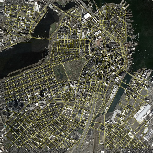 An example of how RoadTracer works to map out a portion of Boston. Source: MIT CSAIL“RoadTracer is well-suited to map areas of the world where maps are frequently out of date, which includes both places with lower population and areas where there’s frequent construction,” says Mohammad Alizadeh, MIT professor and researcher of the project. “For example, existing maps for remote areas like rural Thailand are missing many roads. RoadTracer could help make them more accurate.”
In testing, RoadTracer was able to correctly map 44 percent of its road junctions, which is more than twice as effective as traditional approaches based on image segmentation that could map only 19 percent, MIT CSAIL says.
How It Works
RoadTracer creates maps step-by-step starting at a known location on the road and uses a neural network to examine the surrounding area to determine which point is most likely to be the next part of the road. The system then adds that point and repeats the process to gradually trace out the road one step at a time.
This differs from current efforts that involve training neural networks to look at aerial images and identify individual pixels as either a road or not a road. This requires a post-processing step that’s aimed to fill in the gaps because aerial images can be ambiguous.
“Rather than making thousands of different decisions at once about whether various pixels represent parts of a road, RoadTracer focuses on the simpler problem of figuring out which direction to follow when starting from a particular spot that we know is a road,” says Fayven Bastani, a MIT graduate student involved in the research. “This is in many ways actually a lot closer to how we as humans construct mental models of the world around us.”
The MIT team trained the system on aerial images of 25 cities across six countries in North America and Europe and then evaluated its mapping abilities on 15 other cities. RoadTracer had an error rate that is 45 percent lower than current methods, making automatic mapping system more practical for companies like Google.
“What’s clear is that with a system like ours you could dramatically decrease the amount of tedious work that humans would have to do,” Alizadeh says.
MIT says the incremental approach to RoadTracer makes it much easier to correct errors as human supervisors can simply correct them and re-run the algorithm from where they left off, rather than continue to use imprecise information that trickles down to other parts of the map.
The full research can be found in a new paper from MIT CSAIL, which you can read here.
